Air Ambulance Helicopter to Rushden, Quorn Road
Thursday, 29 January 2026 | 14:06 | From Baginton
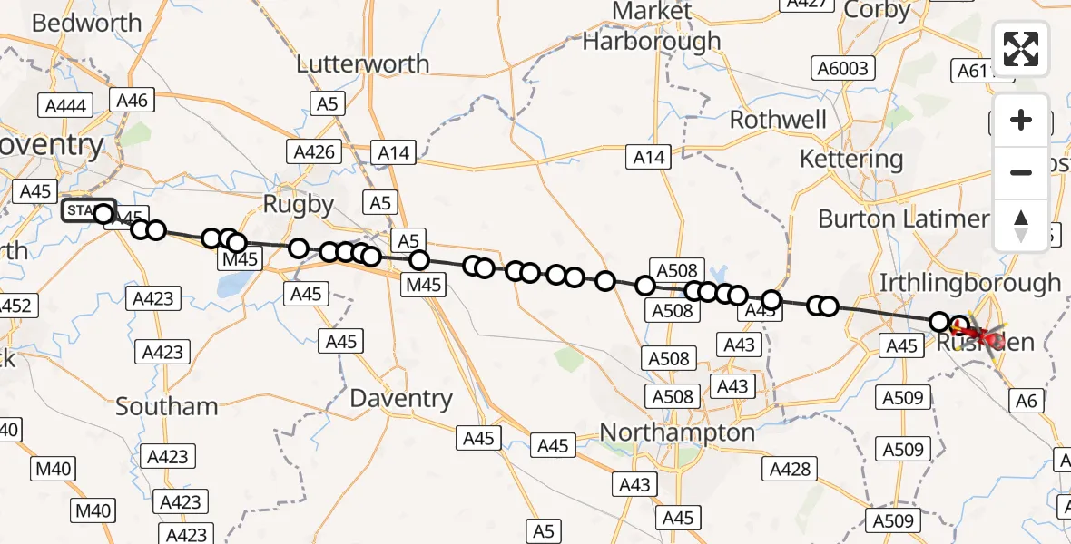
On Thursday, 29 January 2026 at 14:06, a Air Ambulance Helicopter departed from Baginton to Rushden. It was the Air Ambulance Helicopter with registration number G-WNAS. The flight lasted 16 minutes. During that period, the aircraft travelled 37 miles at an average speed of 140 miles per hour at a maximum altitude of 1750 feet.

Helicopter: G-WNAS
The helicopter G-WNAS is used as an ambulance helicopter. The helicopter is equipped with a stretcher for transporting patients. The helicopter is often used to transport to hospitals.
Photo: Tony Melony
38 miles
1750 feet
140 mph
17 minutes
14:06
14:22

Route
Quorn Road, 14:22
Rushden14:21
Irchester14:20
Wellingborough14:19
Mears Ashby14:18
Sywell14:18
Holcot14:17
Pitsford14:17
Brixworth14:17
Pitsford Water14:16
Brixworth14:16
Spratton14:15
Teeton14:14
Coton14:14
Ravensthorpe14:14
West Haddon14:13
Long Buckby14:13
West Haddon14:13
Crick14:12
Kilsby14:11
Barby14:11
Crick14:10
Barby14:10
Rugby14:10
Dunchurch, Rugby14:09
Rugby14:08
RAF Church Lawford, Coventry, Warwickshire14:08
Stretton on Dunsmore CP, Rugby14:07
Rugby14:07
Ryton-on-Dunsmore, Rugby14:06
Siskin Drive, Warwick14:06
Live flights
Coastguard Helicopter on its way from North Sea14 Jul 23:44
Today
Air Ambulance Helicopter to Redhill Aerodrome14 Jul 23:46
Police Helicopter to Johnstone, Gordon Square14 Jul 23:38
Coastguard Helicopter to North Sea14 Jul 23:30
Police Helicopter to Inner Seas14 Jul 23:12
Air Ambulance Helicopter to Norwich Airport14 Jul 22:52
Police Helicopter to Manchester Barton Aerodrome14 Jul 22:50
Police Helicopter to Sewardstonebury, Bury Road14 Jul 22:44
Flights Rushden
Air Ambulance Helicopter to Coventry Airport21 Mar 12:55
Air Ambulance Helicopter to Rushden, Quorn Road29 Jan 14:06
Flights Baginton
Air Ambulance Helicopter to Hunningham21 Mar 10:06
Air Ambulance Helicopter to Meriden, Main Road18 Mar 13:59
Air Ambulance Helicopter to Onley, Onley Road10 Mar 09:29
Air Ambulance Helicopter to Coventry Airport7 Mar 15:55
Helicopter flights on your website?
You can easily display helicopter flights on your own website. Use the embed code.
