Police Helicopter to MOD St Athan
Tuesday, 21 April 2026 | 20:39 | From Bryn
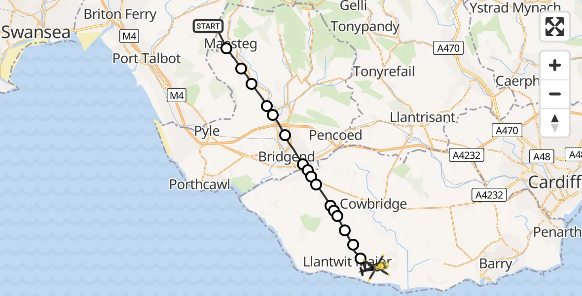
On Tuesday, 21 April 2026 at 20:39, a Police Helicopter departed from Bryn to MOD St Athan. It was the Police Helicopter with registration number G-NWOI. The flight lasted 9 minutes. During that period, the aircraft travelled 21 miles at an average speed of 132 miles per hour at a maximum altitude of 1550 feet.
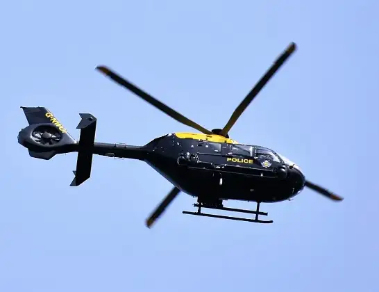
Helicopter: G-NWOI
The helicopter G-NWOI is used by the British police. The helicopter is deployed in pursuits, missing persons cases and other incidents where a helicopter provides added value.
Photo: Alec Wilson
21 miles
1550 feet
132 mph
10 minutes
20:39
20:48

Route
MOD St Athan, St Athan, Vale of Glamorgan20:48
Boverton, Vale of Glamorgan20:47
Llanmaes, Vale of Glamorgan20:47
Sigingstone, Vale of Glamorgan20:46
Llysworney, Vale of Glamorgan20:46
Llandow, Vale of Glamorgan20:46
Llysworney, Vale of Glamorgan20:46
Colwinston, Vale of Glamorgan20:45
Bridgend, Bridgend20:44
Coychurch, Bridgend20:44
Corntown, Vale of Glamorgan20:44
Bridgend, Bridgend20:43
Sarn, Bridgend20:42
Tondu, Bridgend20:42
Coytrahen, Bridgend20:41
Llangynwyd, Bridgend20:41
Maesteg, Bridgend20:40
FP 10/139.PT/1, Neath Port Talbot20:39
Live flights
Today
Flights Bryn
Air Ambulance Helicopter to Dafen, Heol Aur17 Jul 18:21
Air Ambulance Helicopter to Bryn, Meadow Row17 Jul 16:49
Police Helicopter to MOD St Athan16 Jul 11:46
Police Helicopter to Bryn, Brynteg Street16 Jul 11:36
Police Helicopter to Almondsbury Helicopter Base27 Jun 14:57
Police Helicopter to Bryn, Port Talbot3 May 19:02
Police Helicopter to MOD St Athan21 Apr 20:39
Police Helicopter to Pontypool4 Mar 13:35
Police Helicopter to Manchester Barton Aerodrome10 Jan 00:33
Helicopter flights on your website?
You can easily display helicopter flights on your own website. Use the embed code.
