Air Ambulance Helicopter to Ynysmeudwy, Llanguicke Road
Friday, 13 March 2026 | 14:31 | From Dafen
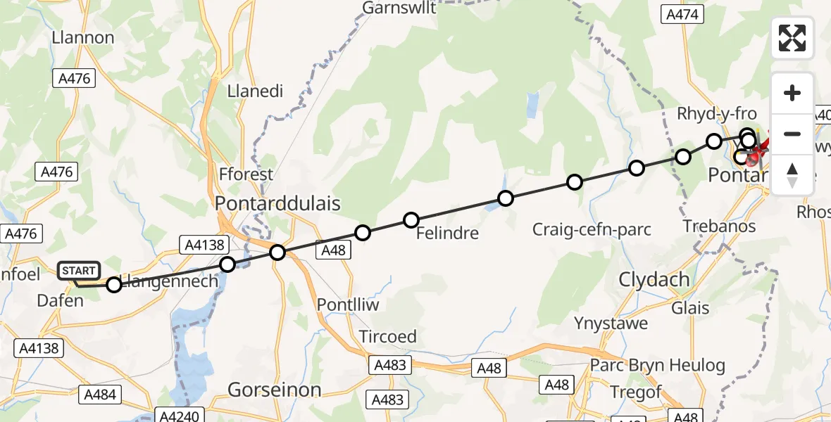
On Friday, 13 March 2026 at 14:31, a Air Ambulance Helicopter departed from Dafen to Ynysmeudwy. It was the Air Ambulance Helicopter with registration number G-WYDN. The flight lasted 7 minutes. During that period, the aircraft travelled 13 miles at an average speed of 120 miles per hour at a maximum altitude of 1675 feet.

Helicopter: G-WYDN
The helicopter G-WYDN is used as a air ambulance helicopter. The main purpose of this aircraft is to transport a Mobile Medical Team to an incident as quickly as possible, enabling the trauma doctor to provide immediate first aid on site. The aircraft is flying this flight as Air Ambulance Helicopter.
Photo: Tony Melony
14 miles
1675 feet
120 mph
7 minutes
14:31
14:37

Route
Llanguicke Road, Pontardawe14:37
Ynysmeudwy, Pontardawe14:37
Rhyd-y-fro, Pontardawe14:36
Ynysmeudwy, Pontardawe14:36
Rhyd-y-fro, Pontardawe14:36
Pontardawe, Pontardawe14:35
Pontardawe, Pontardawe14:35
Craig-cefn-parc, Craig-cefn-parc14:35
Mawr, Mawr14:34
Felindre, Felindre14:34
Pontlliw, Pontlliw14:33
Pontarddulais, Pontarddulais14:33
Hendy, Hendy14:33
Llangennech, Llangennech14:32
Heol Aur, Dafen14:31
Today
Flights Ynysmeudwy
Police Helicopter to MOD St Athan19 Mar 19:15
Flights Dafen
Air Ambulance Helicopter to Dafen, Heol Aur13 Jul 18:27
Air Ambulance Helicopter to Barry, Waycock Road13 Jul 14:28
Air Ambulance Helicopter to Dafen, Heol Aur13 Jul 12:46
Air Ambulance Helicopter to Cray13 Jul 10:03
Air Ambulance Helicopter to Dafen, Heol Aur12 Jul 16:00
Air Ambulance Helicopter to Nantmel, A4412 Jul 13:50
Air Ambulance Helicopter to Dafen, Heol Aur12 Jul 08:18
Air Ambulance Helicopter to Dafen, Heol Aur11 Jul 18:18
Air Ambulance Helicopter to Llywel11 Jul 15:17
Air Ambulance Helicopter to Dafen, Heol Aur11 Jul 11:03
Helicopter flights on your website?
You can easily display helicopter flights on your own website. Use the embed code.
