Police Helicopter to Llangoed, Penmon Point Toll Road
Friday, 12 June 2026 | 23:44 | From Caernarfon
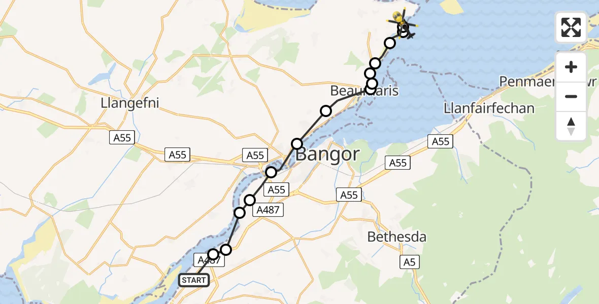
On Friday, 12 June 2026 at 23:44, a Police Helicopter departed from Caernarfon to Llangoed. It was the Police Helicopter with registration number G-POLC. The flight lasted 7 minutes. During that period, the aircraft travelled 14 miles at an average speed of 116 miles per hour at a maximum altitude of 1300 feet.

Helicopter: G-POLC
The helicopter G-POLC is used by the British police. The helicopter is deployed in pursuits, missing persons cases and other incidents where a helicopter provides added value.
Photo: Alec Wilson
14 miles
1300 feet
116 mph
7 minutes
23:44
23:51

Route
Penmon Point Toll Road, Isle of Anglesey23:51
Llangoed, Isle of Anglesey23:51
Llangoed23:50
Beaumaris, Isle of Anglesey23:49
Llanfaes, Isle of Anglesey23:48
Beaumaris, Isle of Anglesey23:48
Llanfaes23:48
Beaumaris23:48
Beaumaris, Isle of Anglesey23:47
Cwm Cadnant23:46
Menai Bridge23:46
Llanfairpwllgwyngyll, Gwynedd23:45
Y Felinheli, Gwynedd23:45
Brynsiencyn, Gwynedd23:44
Y Felinheli, Gwynedd23:44
Caernarfon, Gwynedd23:44
Live flights
Today
Flights Llangoed
Police Helicopter to Llangoed, B510915 Jul 20:05
Police Helicopter to Llanfaes, B510912 Jun 23:02
Police Helicopter to Llangoed12 Jun 22:59
Police Helicopter to Llangoed12 Jun 22:48
Police Helicopter to Llangoed12 Jun 22:41
Flights Caernarfon
Air Ambulance Helicopter to Caernarfon9 Jul 18:09
Helicopter flights on your website?
You can easily display helicopter flights on your own website. Use the embed code.
