Air Ambulance Helicopter to Bednall, Acton Hill Lane
Thursday, 19 March 2026 | 16:31 | From RAF Cosford
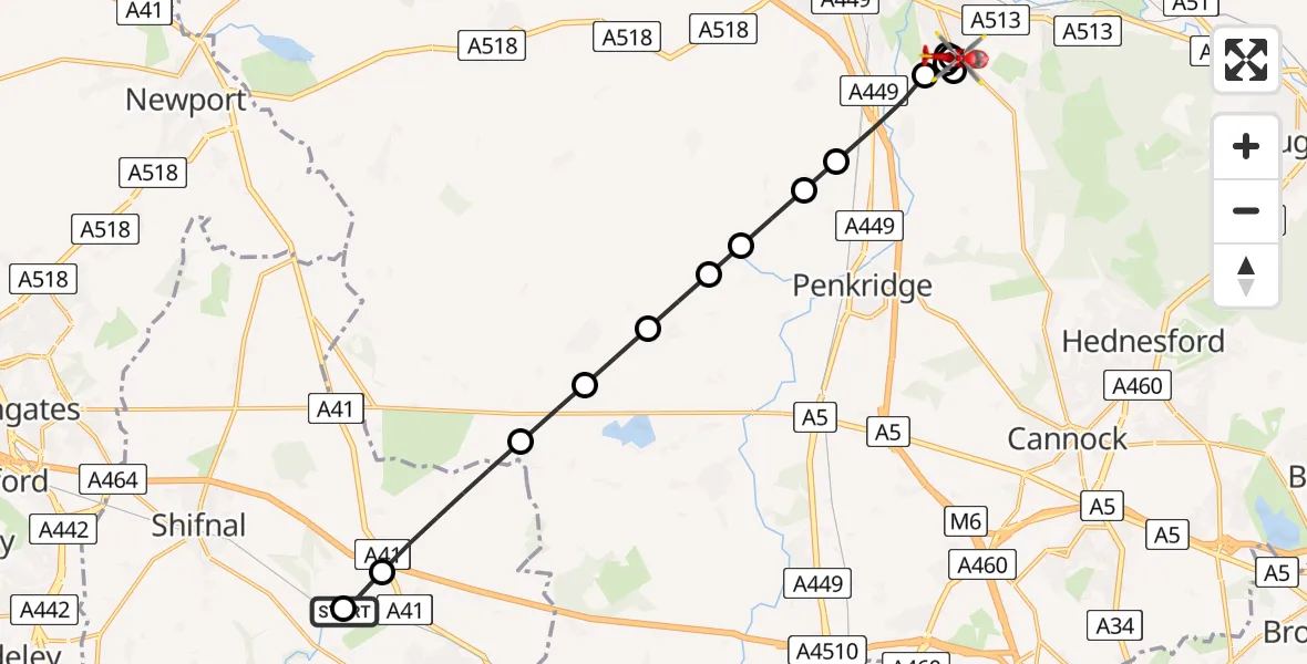
On Thursday, 19 March 2026 at 16:31, a Air Ambulance Helicopter departed from RAF Cosford to Bednall. It was the Air Ambulance Helicopter with registration number G-RMAA. The flight lasted 9 minutes. During that period, the aircraft travelled 14 miles at an average speed of 100 miles per hour at a maximum altitude of 850 feet.
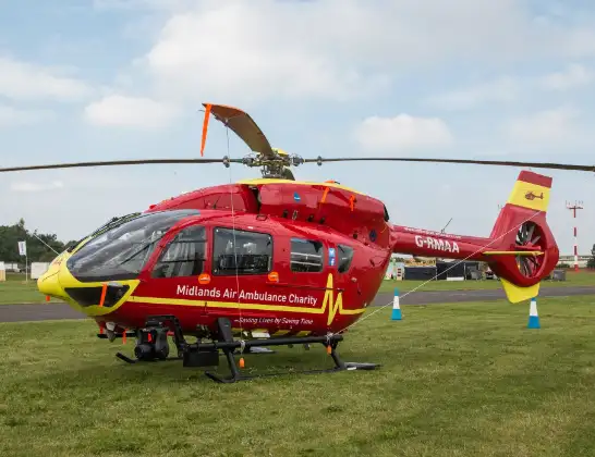
Helicopter: G-RMAA
The helicopter G-RMAA is used as a air ambulance helicopter. The main purpose of this aircraft is to transport a Mobile Medical Team to an incident as quickly as possible, enabling the trauma doctor to provide immediate first aid on site. The aircraft is flying this flight as Air Ambulance Helicopter.
Photo: Steve Lynes
15 miles
850 feet
100 mph
9 minutes
16:31
16:39

Route
Acton Hill Lane, South Staffordshire16:39
Bednall, South Staffordshire16:39
South Staffordshire, South Staffordshire16:39
Bednall, South Staffordshire16:39
Walton on the Hill, Stafford16:38
South Staffordshire, South Staffordshire16:38
Acton Trussell, South Staffordshire16:37
South Staffordshire, South Staffordshire16:36
Penkridge, South Staffordshire16:36
Lapley, Penkridge16:35
Lapley, South Staffordshire16:35
Wheaton Aston, South Staffordshire16:34
Bishops Wood, South Staffordshire16:33
Tong Interchange, Tong16:32
Cosford, Cosford16:31
RAF Cosford, Cosford16:31
Live flights
Police Helicopter on its way from Ewelme13 Jul 22:24
Today
Police Helicopter to Bournemouth Airport13 Jul 23:55
Air Ambulance Helicopter to Cardiff Heliport13 Jul 23:38
Police Helicopter to Birmingham Airport13 Jul 23:21
Police Helicopter to Irlam, Twelve Yards Road13 Jul 23:00
Flights Bednall
Helicopter flights on your website?
You can easily display helicopter flights on your own website. Use the embed code.
