Police Helicopter to Monknash
Tuesday, 10 March 2026 | 15:34 | From Boverton
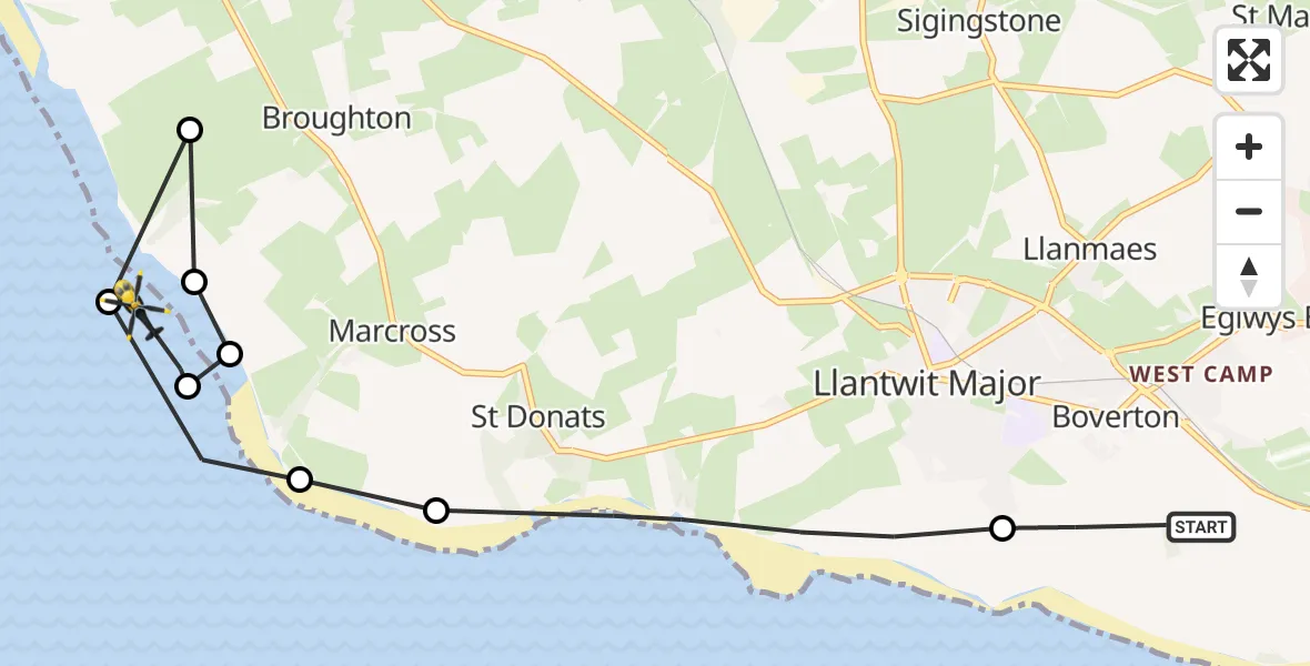
On Tuesday, 10 March 2026 at 15:34, a Police Helicopter departed from Boverton to Monknash. It was the Police Helicopter with registration number G-NWOI. The flight lasted 4 minutes. During that period, the aircraft travelled 9 miles at an average speed of 120 miles per hour at a maximum altitude of 900 feet.
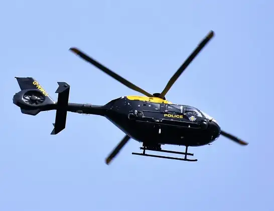
Helicopter: G-NWOI
The helicopter G-NWOI is used by the British police. The helicopter is deployed in pursuits, missing persons cases and other incidents where a helicopter provides added value.
Photo: Alec Wilson
9 miles
900 feet
120 mph
5 minutes
15:34
15:38

Route
Monknash, Monknash15:38
Monknash, Monknash15:37
St. Donats, St. Donats15:37
Monknash, Monknash15:37
Broughton, Broughton15:36
Monknash, Monknash15:36
Marcross, Marcross15:36
St. Donats, St. Donats15:35
Llantwit Major, Llantwit Major15:34
Mill Lane, Boverton15:34
Live flights
Police Helicopter on its way from Ewelme13 Jul 22:24
Today
Police Helicopter to Bournemouth Airport13 Jul 23:55
Air Ambulance Helicopter to Cardiff Heliport13 Jul 23:38
Police Helicopter to Birmingham Airport13 Jul 23:21
Police Helicopter to Irlam, Twelve Yards Road13 Jul 23:00
Flights Monknash
Police Helicopter to Monknash10 Mar 15:34
Flights Boverton
Police Helicopter to Boverton, Llanmaes10 Jul 19:54
Police Helicopter to Bonvilston, Boverton Road10 Jul 01:05
Police Helicopter to MOD St Athan9 Jul 22:18
Police Helicopter to Almondsbury Helicopter Base15 Jun 16:12
Police Helicopter to Coytrahen, Bridgend Road31 May 20:28
Police Helicopter to Bristol Channel31 May 13:03
Police Helicopter to MOD St Athan31 May 11:10
Helicopter flights on your website?
You can easily display helicopter flights on your own website. Use the embed code.
