Air Ambulance Helicopter to Sunderland, Cook Square
Wednesday, 4 March 2026 | 13:56 | From South Bedburn

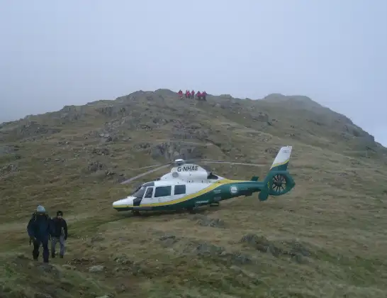
On Wednesday, 4 March 2026 at 13:56, a Air Ambulance Helicopter departed from South Bedburn to Sunderland. It was the Air Ambulance Helicopter with registration number G-NHAE. The flight lasted 11 minutes. During that period, the aircraft travelled 30 miles at an average speed of 170 miles per hour at a maximum altitude of 2025 feet.
Helicopter: G-NHAE
The helicopter G-NHAE is used as a air ambulance helicopter. The main purpose of this aircraft is to transport a Mobile Medical Team to an incident as quickly as possible, enabling the trauma doctor to provide immediate first aid on site. The aircraft is flying this flight as Air Ambulance Helicopter.
Photo: Michael Earnshaw
31 miles
2025 feet
170 mph
11 minutes
13:56
14:07

Route
Cook Square, North East14:07
Sunderland, North East14:05
Washington, Sunderland14:04
South Pelaw, North East14:03
South Pelaw, Chester-le-Street14:03
Pelton Fell, Chester-le-Street14:02
Edmondsley, North East14:02
Witton Gilbert, North East14:02
Burnhope, North East14:01
Langley Park, North East14:01
Esh, North East14:01
Cornsay Colliery, North East14:00
Tow Law, North East13:59
Wolsingham, North East13:57
South Bedburn, North East13:56
Live flights
Today
Coastguard Drone to Noordzee01:52:53
Flights Sunderland
Air Ambulance Helicopter to Sunderland17 Jul 17:01
Air Ambulance Helicopter to New Cowper, B530128 Jun 13:18
Air Ambulance Helicopter to Sunderland, A59128 Jun 11:40
Police Helicopter to Sunderland6 Jun 23:11
Police Helicopter to Sunderland, Park Lea31 Mar 19:54
Air Ambulance Helicopter to Ousby4 Mar 14:47
Helicopter flights on your website?
You can easily display helicopter flights on your own website. Use the embed code.
