Air Ambulance Helicopter to Hill Croome, M5
Saturday, 21 February 2026 | 16:15 | From Ripple
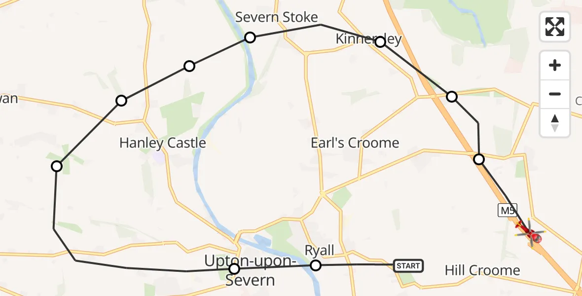
On Saturday, 21 February 2026 at 16:15, a Air Ambulance Helicopter departed from Ripple to Hill Croome. It was the Air Ambulance Helicopter with registration number G-OMAA. The flight lasted 5 minutes. During that period, the aircraft travelled 10 miles at an average speed of 124 miles per hour at a maximum altitude of 1325 feet.
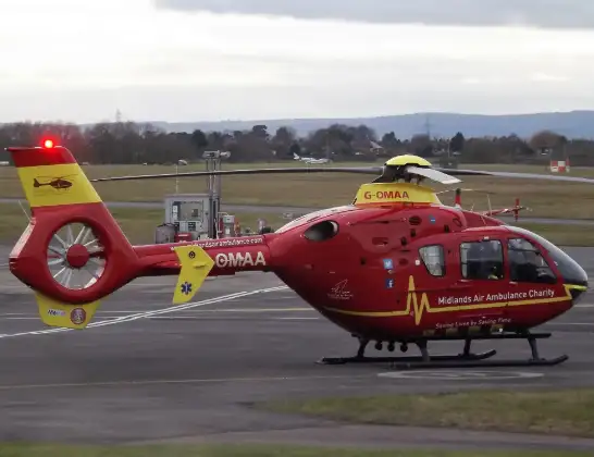
Helicopter: G-OMAA
The helicopter G-OMAA is used as a air ambulance helicopter. The main purpose of this aircraft is to transport a Mobile Medical Team to an incident as quickly as possible, enabling the trauma doctor to provide immediate first aid on site. The aircraft is flying this flight as Air Ambulance Helicopter.
Photo: James from Cheltenham, Gloucestershire
10 miles
1325 feet
124 mph
5 minutes
16:15
16:20

Route
M5, Malvern Hills16:20
Hill Croome, Malvern Hills16:20
Earl's Croome, Malvern Hills16:19
Kinnersley, Worcester16:19
Severn Stoke, Malvern Hills16:18
Hanley Castle, Malvern Hills16:18
Hanley Castle, Upton-upon-Severn16:18
Hanley Castle, Malvern Hills16:18
Upton-upon-Severn, Malvern Hills16:16
Ripple, Worcester16:16
Strensham Road, Malvern Hills16:15
Live flights
Police Helicopter on its way from Glasgow5 Jul 23:05
Today
Air Ambulance Helicopter to North Sea5 Jul 22:14
Police Helicopter to Solihull, Centro Way5 Jul 22:09
Police Helicopter to Hawarden Airport5 Jul 21:47
Air Ambulance Aircraft to North Sea5 Jul 21:33
Police Helicopter to Caergwrle, Stryt Isa5 Jul 21:25
Flights Ripple
Air Ambulance Helicopter to Hill Croome, M511 Apr 13:49
Air Ambulance Helicopter to Ripple, Ryall Lane11 Apr 13:46
Air Ambulance Helicopter to Aymestrey12 Mar 14:33
Air Ambulance Helicopter to Hill Croome, M521 Feb 16:15
Helicopter flights on your website?
You can easily display helicopter flights on your own website. Use the embed code.
