Air Ambulance Helicopter to Bovingdon, Lysander Close
Wednesday, 4 February 2026 | 14:42 | From Stevenage
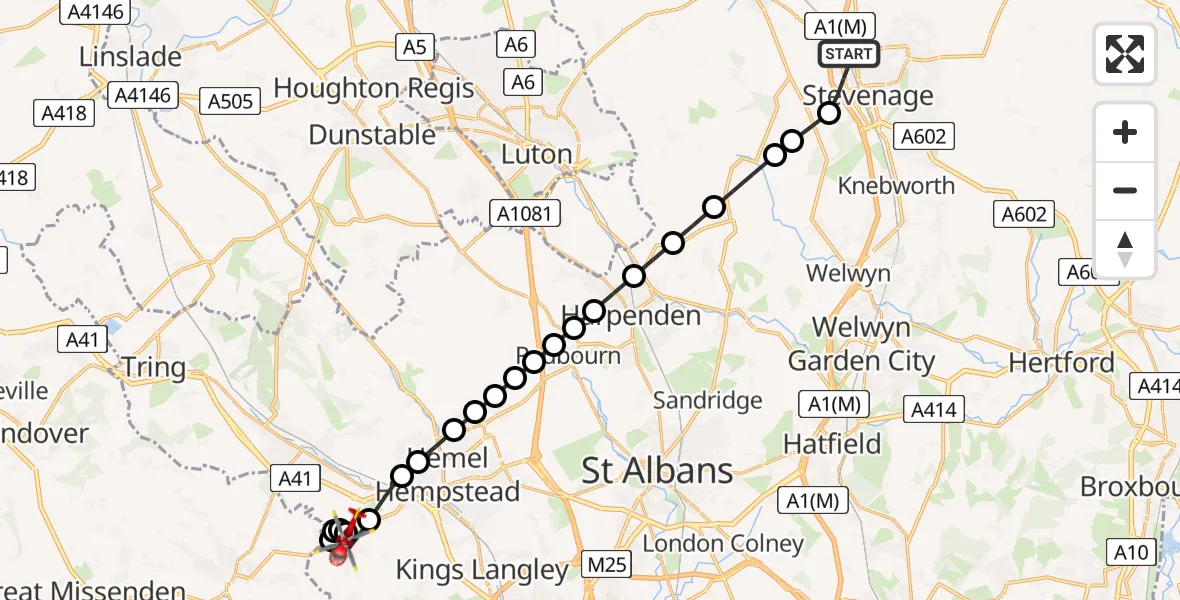
On Wednesday, 4 February 2026 at 14:42, a Air Ambulance Helicopter departed from Stevenage to Bovingdon. It was the Air Ambulance Helicopter with registration number G-EHAT. The flight lasted 13 minutes. During that period, the aircraft travelled 21 miles at an average speed of 101 miles per hour at a maximum altitude of 1950 feet.

Helicopter: G-EHAT
The helicopter G-EHAT is used as a air ambulance helicopter. The main purpose of this aircraft is to transport a Mobile Medical Team to an incident as quickly as possible, enabling the trauma doctor to provide immediate first aid on site. The aircraft is flying this flight as Air Ambulance Helicopter.
Photo: By Steve Knight
22 miles
1950 feet
101 mph
13 minutes
14:42
14:55

Route
Lysander Close, Dacorum14:55
Bovingdon, Dacorum14:54
RAF Bovingdon, Hemel Hempstead, Hertfordshire14:54
Bovingdon Airstrip, Hemel Hempstead, Hertfordshire14:53
RAF Bovingdon, Hemel Hempstead, Hertfordshire14:53
Bovingdon, Dacorum14:52
Bourne End, Dacorum14:51
Old Town, Dacorum14:51
Piccotts End, Dacorum14:51
Hemel Hempstead, Dacorum14:50
Dacorum14:50
Redbourn, St Albans14:50
Dacorum14:50
Redbourn, St Albans14:49
St Albans14:49
Hatching Green, St Albans14:49
Harpenden, St Albans14:48
Wheathampstead, St Albans14:48
Kimpton, North Hertfordshire14:47
St Paul's Walden, North Hertfordshire14:47
Knebworth, North Hertfordshire14:46
North Hertfordshire14:46
Hitchin Road, 14:44
Stevenage14:42
Live flights
Today
Flights Bovingdon
Air Ambulance Helicopter to Elstree Airfield18 Jun 13:15
Air Ambulance Helicopter to Elstree Airfield4 Feb 15:39
Flights Stevenage
Air Ambulance Helicopter to North Weald Airfield29 May 12:28
Air Ambulance Helicopter to North Weald Airfield24 May 14:21
Air Ambulance Helicopter to North Weald Airfield20 May 12:51
Air Ambulance Helicopter to Luton, Moor Path4 May 12:10
Helicopter flights on your website?
You can easily display helicopter flights on your own website. Use the embed code.
