Police Helicopter to Newcastle International Airport, Newcastle International Airport
Wednesday, 14 January 2026 | 20:24 | From Seaham
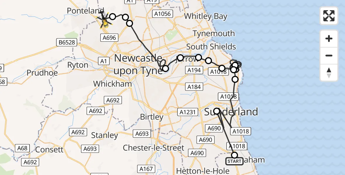
On Wednesday, 14 January 2026 at 20:24, a Police Helicopter departed from Seaham to Newcastle International Airport. It was the Police Helicopter with registration number G-POLA. The flight lasted 27 minutes. During that period, the aircraft travelled 45 miles at an average speed of 101 miles per hour at a maximum altitude of 1850 feet.
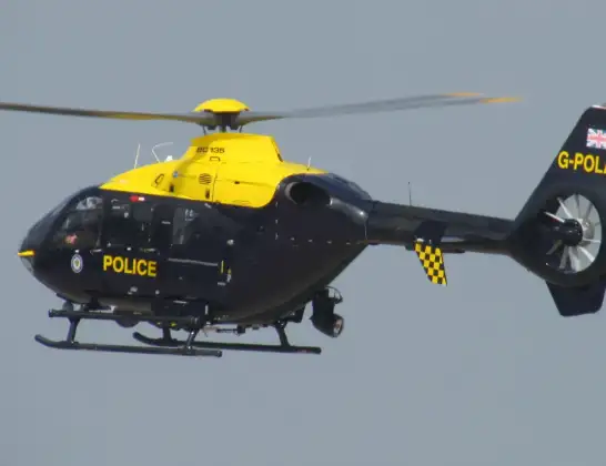
Helicopter: G-POLA
The helicopter G-POLA is used by the British police. The helicopter is deployed in pursuits, missing persons cases and other incidents where a helicopter provides added value.
Photo: ozz13x
45 miles
1850 feet
101 mph
27 minutes
20:24
20:51

Route
Newcastle International Airport, Newcastle upon Tyne, Tyne and Wear20:51
Newcastle International Airport, Newcastle upon Tyne, Tyne and Wear20:50
Dinnington, Newcastle upon Tyne20:49
Hazlerigg Village, Newcastle upon Tyne20:49
Newcastle upon Tyne, North East20:44
Hebburn, South Tyneside20:43
Jarrow, South Tyneside20:42
South Shields, South Tyneside20:42
South Tyneside, North East20:41
Whitburn, South Tyneside20:40
South Tyneside, North East20:33
Whitburn, South Tyneside20:33
South Tyneside, North East20:31
Whitburn, South Tyneside20:30
South Tyneside, North East20:29
Whitburn, South Tyneside20:28
Sunderland, North East20:25
Seaton with Slingley, North East20:25
Warkworth Crescent, North East20:24
Live flights
Today
Police Helicopter to Epping Forest, Green Lane26 Feb 23:43
Flights Seaham
Police Helicopter to Seaham, A1930 Jan 01:31
Police Helicopter to Seaham, Dene Road15 Jan 21:44
Police Helicopter to Seaham, Weybourne Lea14 Jan 19:43
Helicopter flights on your website?
You can easily display helicopter flights on your own website. Use the embed code.
