Coastguard Helicopter to Roos, Hogsea Lane
Friday, 1 May 2026 | 15:09 | From Humberside Airport
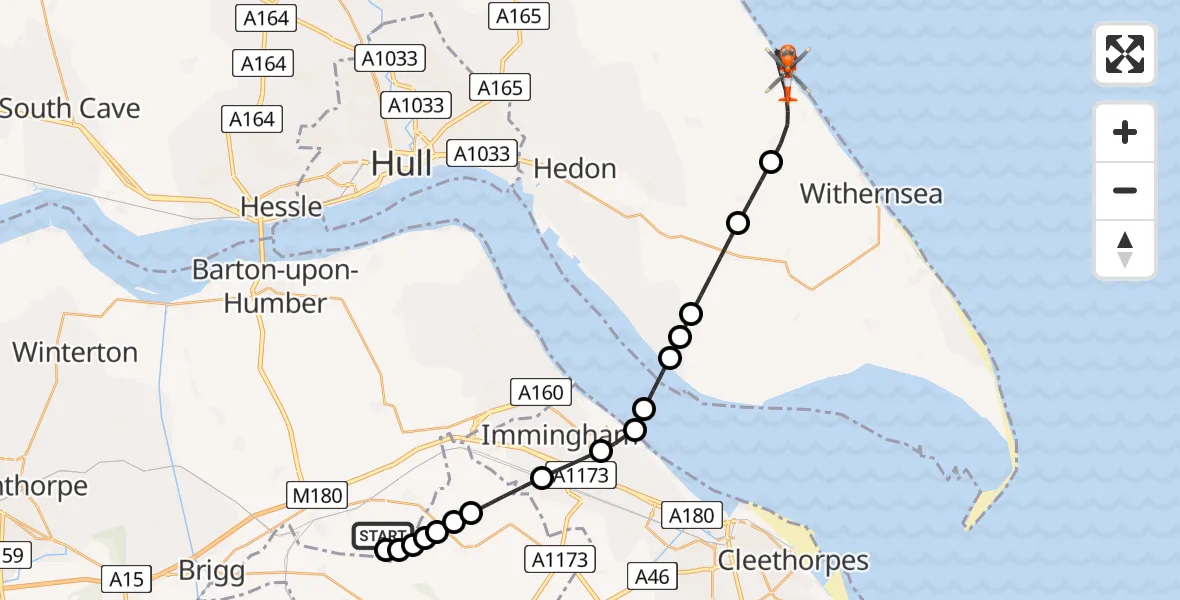
On Friday, 1 May 2026 at 15:09, a Coastguard Helicopter departed from Humberside Airport to Roos. It was the Coastguard Helicopter with registration number G-MCGE. The flight lasted 17 minutes. During that period, the aircraft travelled 26 miles at an average speed of 91 miles per hour at a maximum altitude of 1575 feet.
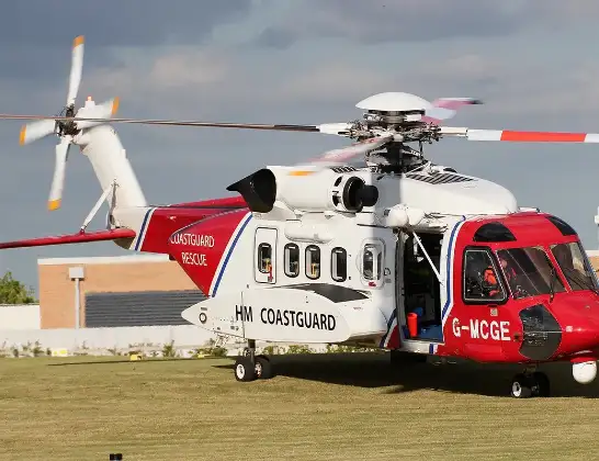
Helicopter: G-MCGE
The helicopter G-MCGE is used by the British Coastguard. The helicopter is deployed in search and rescue operations at sea, rescue operations involving ships or drilling platforms, patrols to prevent smuggling or piracy, environmental monitoring and disaster relief support.
Photo: Mike Burdett
26 miles
1575 feet
91 mph
17 minutes
15:09
15:26

Route
Roos, East Riding of Yorkshire15:26
Hogsea Lane, East Riding of Yorkshire15:26
Roos, East Riding of Yorkshire15:24
Roos, East Riding of Yorkshire15:17
Halsham, East Riding of Yorkshire15:16
Ottringham, East Riding of Yorkshire15:15
Sunk Island, East Riding of Yorkshire15:15
Paull, East Riding of Yorkshire15:14
North Sea15:14
Immingham, North East Lincolnshire15:14
Stallingborough, North East Lincolnshire15:13
Immingham, North East Lincolnshire15:12
West Lindsey, Lincolnshire15:11
Great Limber CP, Lincolnshire15:11
West Lindsey, Lincolnshire15:11
Kirmington, North Lincolnshire15:11
West Lindsey, Lincolnshire15:10
Great Limber CP, North Lincolnshire15:10
Kirmington, North Lincolnshire15:10
Humberside Airport, Grimsby, Lincolnshire15:09
Live flights
Today
Police Helicopter to Hortham, M400:02:34
Flights Roos
Coastguard Helicopter to North Sea15 Jul 16:09
Coastguard Helicopter to Roos, Hogsea Lane15 Jul 15:49
Coastguard Helicopter to Humberside Airport7 Jul 15:35
Coastguard Helicopter to Roos, Pastures Lane7 Jul 15:16
Coastguard Helicopter to North Sea1 Jun 10:51
Coastguard Helicopter to Roos, Pastures Lane1 Jun 10:36
Coastguard Helicopter to Roos, Pastures Lane1 Jun 09:49
Coastguard Helicopter to East Garton20 May 15:01
Coastguard Helicopter to Roos20 May 14:45
Coastguard Helicopter to North Sea1 May 15:28
Helicopter flights on your website?
You can easily display helicopter flights on your own website. Use the embed code.
