Coastguard Helicopter to MOD St Athan
Saturday, 4 April 2026 | 19:10 | From Bristol Airport
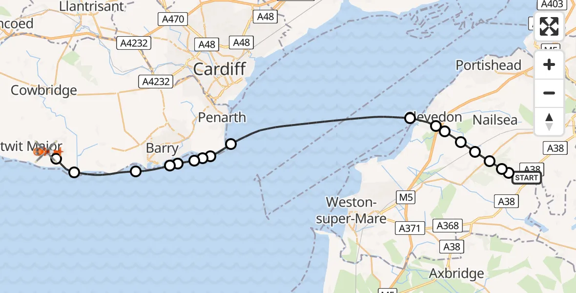
On Saturday, 4 April 2026 at 19:10, a Coastguard Helicopter departed from Bristol Airport to MOD St Athan. It was the Coastguard Helicopter with registration number G-RESI. The flight lasted 23 minutes. During that period, the aircraft travelled 34 miles at an average speed of 90 miles per hour at a maximum altitude of 1625 feet.

Helicopter: G-RESI
The helicopter G-RESI is used by the British Coastguard. The helicopter is deployed in search and rescue operations at sea, rescue operations involving ships or drilling platforms, patrols to prevent smuggling or piracy, environmental monitoring and disaster relief support.
Photo: Tony Melony
35 miles
1625 feet
90 mph
23 minutes
19:10
19:33

Route
MOD St Athan, St Athan, Vale of Glamorgan19:33
MOD St Athan, St Athan, Vale of Glamorgan19:31
West Aberthaw, Vale of Glamorgan19:30
Rhoose, Vale of Glamorgan19:28
Barry, Vale of Glamorgan19:27
Sully and Lavernock, Vale of Glamorgan19:27
Sully, Vale of Glamorgan19:26
Barry, Vale of Glamorgan19:26
Sully, Vale of Glamorgan19:26
Sully and Lavernock, Vale of Glamorgan19:25
Bristol Channel19:20
Clevedon, North Somerset19:19
Kenn, North Somerset19:19
Yatton, North Somerset19:18
Claverham, North Somerset19:18
Cleeve, North Somerset19:17
Wrington, North Somerset19:17
Redhill, North Somerset19:16
Bristol Airport, Bristol19:15
Bristol Airport, Bristol19:10
Live flights
Police Helicopter on its way from Ewelme13 Jul 22:24
Today
Police Helicopter to Bournemouth Airport13 Jul 23:55
Air Ambulance Helicopter to Cardiff Heliport13 Jul 23:38
Police Helicopter to Birmingham Airport13 Jul 23:21
Police Helicopter to Irlam, Twelve Yards Road13 Jul 23:00
Helicopter flights on your website?
You can easily display helicopter flights on your own website. Use the embed code.
