Air Ambulance Helicopter to Bristol, Bishop Manor Road
Sunday, 22 March 2026 | 13:58 | From Cheddar
On Sunday, 22 March 2026 at 13:58, a Air Ambulance Helicopter departed from Cheddar to Bristol. It was the Air Ambulance Helicopter with registration number G-DSAA. The flight lasted 11 minutes. During that period, the aircraft travelled 22 miles at an average speed of 119 miles per hour at a maximum altitude of 1425 feet.
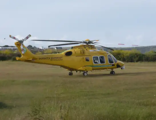
Helicopter: G-DSAA
The helicopter G-DSAA is used as a air ambulance helicopter. The main purpose of this aircraft is to transport a Mobile Medical Team to an incident as quickly as possible, enabling the trauma doctor to provide immediate first aid on site. The aircraft is flying this flight as Air Ambulance Helicopter.
Photo: Andrew Bone
22 miles
1425 feet
119 mph
11 minutes
13:58
14:09

Route
Bristol, West of England14:09
Bishop Manor Road, West of England14:09
Bristol, West of England14:06
Leigh Woods, Leigh Woods14:06
Long Ashton, Long Ashton14:05
Flax Bourton, Flax Bourton14:04
Backwell, Backwell14:04
Wrington, Wrington14:03
Congresbury, Congresbury14:03
Wrington, Wrington14:02
Langford, Langford14:02
Congresbury, Congresbury14:02
Churchill, Churchill14:01
Bristol, Bristol14:01
Banwell, Banwell14:01
Winscombe, Winscombe14:00
Cross, Cross14:00
Lower Weare, Lower Weare14:00
Cross, Cross13:59
Axbridge, Axbridge13:59
Strawberry Line, Cheddar13:58
Today
Flights Bristol
Police Helicopter to Bristol, Oaktree Crescent10 Jul 12:36
Police Helicopter to Bristol, Stoke Lane9 Jul 20:52
Flights Cheddar
Air Ambulance Helicopter to Henstridge Airfield10 May 14:02
Air Ambulance Helicopter to Cheddar10 May 13:23
Police Helicopter to Almondsbury Helicopter Base25 Apr 16:38
Police Helicopter to Cheddar, Warrens Hill Road25 Apr 15:35
Air Ambulance Helicopter to Henstridge Airfield12 Apr 13:57
Helicopter flights on your website?
You can easily display helicopter flights on your own website. Use the embed code.
