Air Ambulance Helicopter to Dafen, Heol Aur
Friday, 13 March 2026 | 18:58 | From Bridgend
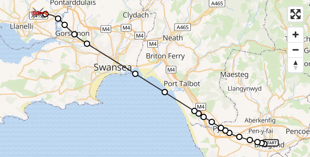
On Friday, 13 March 2026 at 18:58, a Air Ambulance Helicopter departed from Bridgend to Dafen. It was the Air Ambulance Helicopter with registration number G-WYDN. The flight lasted 19 minutes. During that period, the aircraft travelled 27 miles at an average speed of 88 miles per hour at a maximum altitude of 2450 feet.

Helicopter: G-WYDN
The helicopter G-WYDN is used as a air ambulance helicopter. The main purpose of this aircraft is to transport a Mobile Medical Team to an incident as quickly as possible, enabling the trauma doctor to provide immediate first aid on site. The aircraft is flying this flight as Air Ambulance Helicopter.
Photo: Tony Melony
28 miles
2450 feet
88 mph
19 minutes
18:58
19:17

Route
Heol Aur, Dafen19:17
Dafen, Dafen19:15
Llangennech, Llangennech19:14
Gorseinon, Gorseinon19:13
Upper Loughor, Gorseinon19:13
Gorseinon, Gorseinon19:12
Swansea, Swansea19:09
Bristol Channel19:07
Margam Moors, Margam Moors19:05
Eglwys Nunydd Reservoir19:05
Margam, Margam19:04
Coed Hirwaun, Coed Hirwaun19:04
Pyle, Pyle19:03
Kenfig Hill, Kenfig Hill19:03
Pyle, Pyle19:03
Cefn Cribwr, Cefn Cribwr19:02
Laleston, Laleston19:02
Bryntirion, Bryntirion19:01
Cefn Glas, Cefn Glas19:01
Newcastle, Newcastle19:01
Minerva Street, Bridgend18:58
Bridgend, Bridgend18:58
Live flights
Today
Flights Dafen
Air Ambulance Helicopter to Dafen, Heol Aur13 Jul 18:27
Air Ambulance Helicopter to Barry, Waycock Road13 Jul 14:28
Air Ambulance Helicopter to Dafen, Heol Aur13 Jul 12:46
Air Ambulance Helicopter to Cray13 Jul 10:03
Air Ambulance Helicopter to Dafen, Heol Aur12 Jul 16:00
Air Ambulance Helicopter to Nantmel, A4412 Jul 13:50
Air Ambulance Helicopter to Dafen, Heol Aur12 Jul 08:18
Air Ambulance Helicopter to Dafen, Heol Aur11 Jul 18:18
Air Ambulance Helicopter to Llywel11 Jul 15:17
Air Ambulance Helicopter to Dafen, Heol Aur11 Jul 11:03
Flights Bridgend
Air Ambulance Helicopter to Dafen, Heol Aur31 May 18:09
Police Helicopter to Bridgend, Somerset View28 May 12:05
Police Helicopter to Bridgend17 May 16:38
Air Ambulance Helicopter to Cardiff Heliport19 Apr 19:43
Air Ambulance Helicopter to Dafen, Heol Aur19 Apr 19:42
Helicopter flights on your website?
You can easily display helicopter flights on your own website. Use the embed code.
