Air Ambulance Helicopter to Street, Somerton Road
Monday, 23 February 2026 | 10:04 | From Almondsbury Helicopter Base
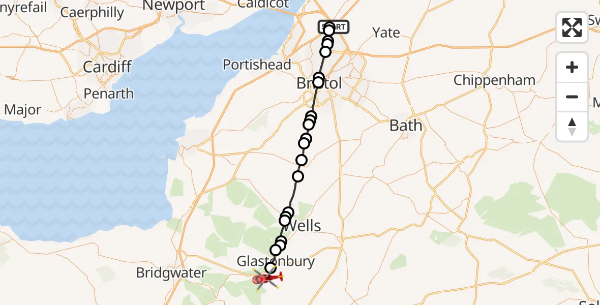
On Monday, 23 February 2026 at 10:04, a Air Ambulance Helicopter departed from Almondsbury Helicopter Base to Street. It was the Air Ambulance Helicopter with registration number G-GWAC. The flight lasted 17 minutes. During that period, the aircraft travelled 33 miles at an average speed of 120 miles per hour at a maximum altitude of 1625 feet.
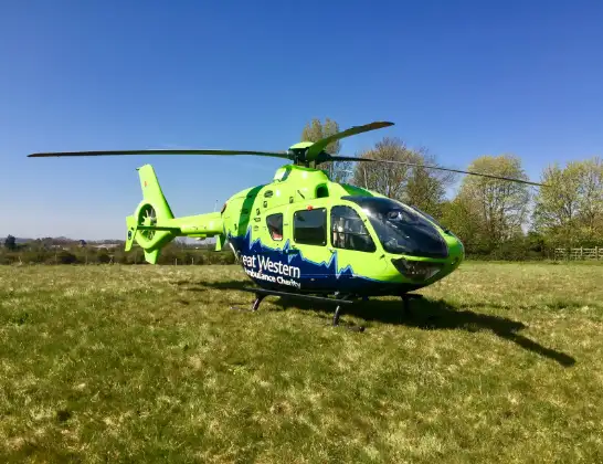
Helicopter: G-GWAC
The helicopter G-GWAC is used as a air ambulance helicopter. The main purpose of this aircraft is to transport a Mobile Medical Team to an incident as quickly as possible, enabling the trauma doctor to provide immediate first aid on site. The aircraft is flying this flight as Air Ambulance Helicopter.
Photo: Mojo0306
34 miles
1625 feet
120 mph
17 minutes
10:04
10:20

Route
Street10:20
Somerton Road, 10:20
Stallgrove Lane, 10:19
Keens Close, 10:19
Strode Road, 10:18
The Boardwalk, 10:18
Glastonbury10:17
St Cuthbert Out10:17
Godney10:17
Wookey10:16
Easton10:15
Wookey Hole10:15
Priddy10:13
Compton Martin, West of England10:12
Chew Stoke, West of England10:11
Bristol, West of England10:11
Chew Magna, West of England10:10
Dundry, West of England10:10
Dundry10:10
Bristol, West of England10:08
Bristol Royal Infirmary Helipad, Bristol10:07
Bristol, West of England10:06
Filton, West of England10:05
Patchway, West of England10:05
Park Avenue, West of England10:04
Almondsbury, West of England10:04
Almondsbury Helicopter Base, Bristol, Somerset10:04
Live flights
Today
Police Helicopter to Epping Forest, Green Lane26 Feb 23:43
Flights Street
Air Ambulance Helicopter to Highworth, Highworth23 Feb 11:29
Helicopter flights on your website?
You can easily display helicopter flights on your own website. Use the embed code.
