Air Ambulance Helicopter to Tunbridge Wells Hospital Heliport, Tunbridge Wells Hospital Heliport
Friday, 30 January 2026 | 13:30 | From Hildenborough

On Friday, 30 January 2026 at 13:30, a Air Ambulance Helicopter departed from Hildenborough to Tunbridge Wells Hospital Heliport. It was the Air Ambulance Helicopter with registration number G-LNAC. The flight lasted 8 minutes. During that period, the aircraft travelled 9 miles at an average speed of 70 miles per hour at a maximum altitude of 1825 feet.
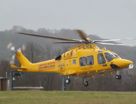
Helicopter: G-LNAC
The helicopter G-LNAC is used as a air ambulance helicopter. The main purpose of this aircraft is to transport a Mobile Medical Team to an incident as quickly as possible, enabling the trauma doctor to provide immediate first aid on site. The aircraft is flying this flight as Air Ambulance Helicopter.
Photo: James from Cheltenham, Gloucestershire
9 miles
1825 feet
70 mph
8 minutes
13:30
13:38

Route
Tunbridge Wells Hospital Heliport, Tunbridge Wells, Kent13:38
Pembury, Royal Tunbridge Wells13:36
Pembury, Tunbridge Wells13:36
Pembury, Royal Tunbridge Wells13:36
Royal Tunbridge Wells, Tunbridge Wells13:35
Pembury, Royal Tunbridge Wells13:35
Pembury, Tunbridge Wells13:34
Capel, Tunbridge Wells13:33
Capel, Tonbridge13:32
Tonbridge, Tonbridge and Malling13:32
Riding Lane, Tonbridge and Malling13:30
Live flights
Today
Flights Hildenborough
Air Ambulance Helicopter to Tunbridge Wells Hospital Heliport, Tunbridge Wells Hospital Heliport30 Jan 13:30
Helicopter flights on your website?
You can easily display helicopter flights on your own website. Use the embed code.
